With everything going on in the world, and noting how the UK tourism industry has changed due to the pandemic, it’s reasonable to expect that more people in the UK will stop taking their holidays abroad and explore more of their home turf.
That’s why we’ve put together this Ultimate Guide For Things To Do In The Lake District For 1st Time Visitors.
Visiting the Lake District is quite easy, whether that's by car, bus, or train.
With human-affected Climate Change increasingly on everyone's conscience, we do recommend you visit the Lake District by bus or train in order to minimise your carbon footprint (but we can also appreciate that that's not always easy to do).
Below we've included a guide to visiting the Lake District by car from different parts of the UK, and also by bus and train, with links to excellent operators and resources.
Aim for the Ⓜ️ M11 North, exit at Junction 6 onto Ⓜ️ M25 towards M1/Watford/Heathrow Airport. After 23 miles, exit Junction 21 onto Ⓜ️ M1/Luton Airport and stay on M1 for 60 miles. At Junction 19 take the Ⓜ️ M6 exit to Birmingham/Coventry, and follow all the way into Cumbria. The journey should take around 5 hours.
aim for the Ⓜ️ M5 The Midlands/London/Bristol/Bridgwater. After 120+ miles merge onto the Ⓜ️ M6 at Junction 8 towards Walsall/Wolverhampton. Follow the Ⓜ️ M6 all the way into Cumbria. The journey should take 4.5–5 hours.
you're aiming for the ? A65 Skipton. Follow the A65 northwest past Long Preston, Settle, Clapham, Ingleton, then Kirkby Lonsdale. Exit the A65 at Junction 36 onto the Ⓜ️ M6. This journey should take around 2 hours.
if coming from Liverpool aim for the ? A5038 and follow signs to the Ⓜ️ M58 Skelmersdale/Preston/M6. After 10+ miles exit the M58 onto the Ⓜ️ M6 at Junction 26. Follow the M6 all the way into Cumbria. If coming from Manchester aim for the ? A580 to merge onto the Ⓜ️ M61 slip road. After 20 miles on the M61 you'll merge onto the Ⓜ️ M6. Follow the M6 all the way into Cumbria. This takes around 1.5 hours.
aim for the Ⓜ️ A1(M) south until you reach Junction 53 Scotch Corner, then head west onto the ? A66. You can follow the A66 all the way towards the North Lake District, or exit the A66 at Junction 40 to get onto the Ⓜ️ M6 South towards the South Lake District. This takes around 1.5–2 hours from Newcastle-upon-Tyne, or about 2.5 hours from Northumberland.
If heading south via Glasgow, follow the Ⓜ️ M8 around Glasgow then exit at Junction 8 onto the Ⓜ️ M73. Two miles later merge onto the Ⓜ️ M74/Carlisle. The M74 becomes the Ⓜ️ M6 after crossing the border into England. If you're heading south via Edinburgh, take the Ⓜ️ M9 down towards the Ⓜ️ M8 and utilise the City of Edinburgh Bypass to exit onto the ? A702. Follow the A702 all the way to join the Ⓜ️ A74(M) at Junction 13 towards Carlisle. The A74(M)/M74 becomes the Ⓜ️ M6 once it crosses the border into England. From Glasgow/Edinburgh area, the journey should take around 2.5–3 hours.
For all routes: The M6 runs along the east side of the Lake District. Exit at Junction 36 onto the A590 for South Lake District (Kendal, Barrow, Windermere, Bowness, Ambleside, Grasmere), or exit the M6 at Junction 40 onto the A66 West for the North Lake District (Keswick, Ullswater, Glenridding, Thirlmere, Cockermouth).
The A590 takes you around the southern part of the Lake District, where you can branch off to explore places like Windermere and Coniston.
From the A590 you can link up with the A595 via the A5092; here, the A595 carries on round and up the Western Lake District, where you can explore some of the most remote yet grandiose parts of the Lake District, not to mention the West Cumbrian Coast.
You can also exit the M6 at Junction 36 to get onto the A591, which takes you all the way through the middle of the Lake District and is often cited as being one of the country's prettiest drives (just check out the image below!)
trains run regularly to Birmingham New Street, then take the Avanti West Coast line to Preston (Lancs), changing there to continue onwards to Oxenholme Lake District.
you’ll either take the Transpennine Express to Manchester Piccadilly and change here to continue onwards to Oxenholme Lake District, or take the Transpennine Express to Manchester Victoria, then onwards to Bolton and change here again to continue on to Oxenholme Lake District.
from Liverpool, take the Northern trains from Liverpool Lime Street. You’ll then change at either Wigan North Western, Manchester Oxford Road, or Preston (Lancs) to continue on to Oxenholme Lake District. From Manchester, there is a direct Northern train from Manchester Piccadilly to Oxenholme Lake District; if not direct, the train will change at Preston (Lancs) before continuing on to Oxenholme Lake District.
at Newcastle take the Northern Trains line to Carlisle. You can then change there to head to Oxenholme Lake District or stay in Carlisle to explore the Northern Lake District.
from Glasgow, the Avanti West Coast line travels direct from Glasgow Central to Oxenholme Lake District. From Edinburgh, take the ScotRail train from Edinburgh Gateway to Haymarket, changing here onto the Transpennine Express to Oxenholme Lake District.
Use Trainline to find times and routes to the Lake District near you.
Visit the Lake District by bus
National Express run coaches to quite a few towns in the Lake District from all over the UK.
Once you're here, the Lake District's local Stagecoach bus service is the best way to explore the area. With scheduled services running from Barrow in the south to Carlise in the north, plus all the towns in between.
Places to visit in the Lake District
It could well be argued that it will take a lifetime to visit all there is to offer in the Lake District National Park.
The Lake District features England's highest mountain (Scafell Pike), England's longest lake (Windermere), England's deepest lake (Wastwater) and everything in between. Whether you want to explore England's highest peaks, sail in England's biggest lakes, swim in the Lake District's innumerable tarns, visit some of England's biggest waterfalls... there's something for everyone.
The Countryside Code
The Countryside Code. Image by Emphyrio from Pixabay
Whether you're on the highest fells, swimming in the lakes, or hiking through the dales, follow the Countryside Code so people of all ages and backgrounds can enjoy the invaluable health and wellbeing benefits that nature offers, while giving it the respect it deserves.
RESPECT EVERYONE
Be considerate to those living in, working in and enjoying the countryside
Leave gates and property as you find them
Do not block access to gateways or driveways when parking
Be nice, say hello, share the space
Follow local signs and keep to marked paths unless wider access is available
PROTECT THE ENVIRONMENT
Take your litter home - leave no trace of your visit
Take care with BBQs and do not light fires
Always keep your dogs under control and in sight
Dog poo - bag it and bin it in any public waste bin
Care for nature - do not cause damage or disturbance
ENJOY THE OUTDOORS
Check your route and local conditions
Plan your adventure - know what to expect and what you can do
Enjoy your visit, have fun, make a memory
Visiting the Lake District lakes
The Lake District, as you would imagine from the name, is home to 16 major lakes although only one is actually called a lake: Bassenthwaite Lake. The rest are known as meres (Windermere, Grasmere, Thirlmere etc.) and waters (Ullswater, Wastwater, Derwentwater etc.)
WINDERMERE
Windermere is the largest natural lake in England, exceeding 11 miles long and nearly a mile wide and its widest point. It covers 5.6 sq mi and is over 200ft deep. Windermere is known as a “ribbon lake”; these are long and deep, finger-shaped lake, usually found in a glacial trough. The lake was formed after the last Ice Age glacier retreated, around 14,700–17,000 years ago.
The name comes from Old Norse, like a lot of place names in Northern England, as well as Old English. “Mere” comes from Old English meaning “lake” or “pool”, where as “Winder-” comes from an Old Norse name, winand or vinand, giving us “Vinander’s lake”.
Click/tap the image for a bigger view
Directions:Come off the M6 at Junction 36 onto the A590 then take the 2nd exit at the Brettargh Holt Roundabout to get onto the A591. Follow the A591 all the way to Windermere town, then take a left at the sign labelled Windermere Town centre/Bowness Town centre. Follow this road through Windermere town all the way to Bowness-on-Windermere. There are lots of car parks throughout Bowness (Quarry Mount, Rayrigg Road, Rectory Road, Glebe Road, Braithwaite Fold, and more) but you may need to do some driving around to find a space as Bowness is very popular.
From wherever you’ve parked though, have a meander around the town. Bowness-on-Windermere is a treasure trove of gorgeous independent shops, cafés, restaurants, pubs, gift shops, and everything in between.
To get to the lake just follow the signs to Bowness Pier where you can drink in the views up and down Windermere and its many islands (including the nearest from Bowness, Belle Island). You’ll also note all the swans and geese who hang around the pier and are very used to people, particular all the people food available!
Bowness-on-Windermere is the home of the famous Windermere Lake Cruises, offering a variety of guided tours around the lake as well as self-drive motor boat hiring and rowing boats. The scenery and experience from a boat is like no other!
Whilst you're wandering around Bowness-on-Windermere, visit our Bowness Herdy shop! Situated next door to Peter Rabbit's Nursery, Herdy is full of design-led gifts, homeware, and accessories that are all made to make ewe smile. Visit Bowness Herdy
ULLSWATER
After Windermere, Ullswater is the 2nd largest lake in the Lake District, measuring about nine miles (14.5 km) long, over half a mile (1.02 km) at its widest point, and just over 60 metres (197 ft) deep.
In contrast to Windermere’s gentle profile and low lying hills, Ullswater is a lot more dramatic featuring as it does some of the Lake District’s highest fells at its head. These include Place Fell (657 m/2,156 ft) along the southeastern shore, Gowbarrow Fell (481 m/1,578 ft) on the northwestern shore, and a ring of fells at the head of Ullswater such as St. Sunday Crag (841 m/2,759 ft), Sheffield Pike (675 m/2,215 ft), and Birkhouse Moor (718 m/2,356 ft).
Of course, all of these fells pale in comparison to one of the Lake District's most popular fell climbs from Ullswater: Helvellyn (950 m/3,117 ft), England's 3rd highest peak.
In 2016 the Ullswater Way opened, a 20-miles circuit of the entire lake. You can take it in either direction or break it up into smaller sections, especially if you take a return journey via the famous Ullswater Steamers!
As a result of all these nearby challenging fells and long-distance walks Ullswater can be busy much like Windermere, but with the more adventurous and outdoorsy type of folk.
Photo by Andrew Wilkinson, licensed CC-BY-SA-2.0
Arguably one of the best ways to experience Ullswater is via a tour of the lake courtesy of the Ullswater Steamers. These boat tours have been in operation for 160 years, and operate an all-year service with connections between Glenridding, Howtown, Pooley Bridge Piers and between Glenridding and National Trust Aira Force Pier. Cruise times vary from 20 – 120 minutes.
There's nothing like experience Ullswater and the surrounding mountains from a boat! Not to mention the fascinating information provided by the tour guides, too.
DERWENTWATER
Photo by DAVID ILIFF. License: CC BY-SA 3.0
Derwentwater is located immediately south of the popular Lake District town Keswick, situated in the North Lakes area. The lake is about 3 miles long, nearly 1¼ miles wide at its widest, and 72 ft deep and its deepest. Derwentwater is known for its incredibly picturesque setting, and has been celebrated in verse and song for centuries.
Derwentwater is home to four main islands: Derwent Isle, Lord's Island, St. Herbert's Island, and Rampsholme Island. Only Derwent Isle is inhabited, featuring a stately house that people can visit 5 times during the year. Both the house and the island are owned by the National Trust. There are other smaller islands in the lake that make sporadic appearances based on how full or dry the lake is.
The view down the lake from Keswick is one of the most celebrated views in the Lake District especially when accessed from Friar's Crag, a short walk from Keswick town.
North of Keswick and looming large above both the town and Derwentwater is England's 4th highest peak: Skiddaw (931 m/3,054 ft). Though one of England's tallest peaks, it's not technically challenging and there are numerous paths one can take to ascend its gentle slopes towards the summit.
South of Derwentwater lies Borrowdale, perhaps the Lake District's most famous valley. Numerous high fells rise sharply from the valley floor here, and there are plenty of smaller tributary valleys that branch off from Borrowdale where one can wander and explore. The B5289 from Keswick travels down the eastern shore of Derwentwater into Borrowdale and beyond. You can even carry on up and over Honister Pass if you're feeling brave!
Visiting Derwentwater from Keswick
Undoubtedly one of the most accessible ways to visit Derwentwater is from Keswick, which sits immediately north of the lake.
Directions: Come off the M6 at Junction 40 onto the A66 west. Follow the A66 all the way into Keswick town centre. There are numerous car parks dotted throughout Keswick (such as Otley Road, Bell Close, Lakeside etc.) but you may need to drive around before you find a suitable space as Keswick can get very busy.
Photo by DAVID ILIFF. License: CC BY-SA 3.0
Keswick is a gorgeous market town rammed full of beautiful independent gift shops, cafés, restaurants, pubs, outdoor retailers, and everything in between.
If you really fancy digging deep into Keswick to see what it has to offer, we've put together a handy-dandy guide for you. Things To Do In Keswick
Do you know what else you can do in Keswick? You can visit the Keswick Herdy shop! Visit Keswick Herdy
GRASMERE
Grasmere is by far one of the smaller lakes of the major Lake District lakes.
The lake is about 1,600 yards long, 700 yards wide at its widest, and 70 ft deep and its deepest. It sits near the geographical centre of the Lake District and is bordered to its east by neighbouring lake Rydal Water. To the west Grasmere is flanked by Silver How (395 m/1,296 ft), to the south by Loughrigg Fell (335 m/1,099 ft), and to the east by Heron Pike (612 m/2,008 ft). Immediately north of the lake is the small yet perfectly formed village of the same name: Grasmere.
Grasmere and its village are places of significant historical interest. They are the resting place of world-famous Romantic poet William Wordsworth, alongside his sister Dorothy Wordsworth. William and Dorothy lived in Dove Cottage, just outside the village, Allan Bank, slightly north of the village, and finally Rydal Mount in nearby Rydal. Other famous Romantic poets also lived, or often visited, Grasmere, such as Samuel Taylor Coleridge and Thomas de Quincy.
Grasmere is often credited as being the birthplace of the National Trust, by founder Canon Hardwicke Drummond Rawnsley. He was reportedly appalled by the sale into private hands of Grasmere's only island, and felt it should be a public property. Not long after, he set up the National Trust with Octavia Hill and Robert Hunter, alongside consultations with the famous Beatrix Potter.
Visiting Grasmere
Directions: Come off the M6 at Junction 36 onto the A590 then take the 2nd exit at the Brettargh Holt Roundabout to get onto the A591. Follow the A591 all the way to Grasmere; you'll pass Windermere, Waterhead, Ambleside, and Rydal along the way.
There are three main car parks in the village, plus some additional on-street disc parking. Grasmere is a small village and is incredibly popular, so finding a free parking spot will be tricky.
Take your time to wander around this historic and impossibly pretty village. We've put together a guide already, jam packed with suggestions and ideas on what to do in and around Grasmere. Things To Do In Grasmere
No visit to Grasmere is complete without checking out our Grasmere Herdy Shop, the first ever brick 'n' mortar shop we ever opened way back in 2010! Visit Grasmere Herdy
Getting to Grasmere lake from the village is super easy.
Starting at the Herdy Grasmere shop (///cured.spring.credible), head south down College Street and continue onto Church Stile, passing the Wordsworth Hotel, the Daffodil Gardens, and the Grasmere Gingerbread Shop. Take the right turn onto Red Bank and follow it, passing the Potting Shed Café and the Grand At Grasmere. Take a left turn to continue onto Red Bank.
Eventually you'll see a footpath sign directing you to the lake, complete with a National Trust sign and gate. Head through the gate and down the path all the way to the lake shore. You can then follow the lakeshore path to the lake's gravelly southeastern beach, to enjoy the wonderful views across the lake towards the fells, especially Helm Crag.
CONISTON WATER
Much like Grasmere, Coniston Water is steeped in history—both recent and ancient—and cultural significance.
Coniston Water is the 3rd largest lake in the Lake District by volume, and the 5th largest by area, measuring five miles long and half a mile wide at its widest point. Similar to Windermere, Coniston Water is a classic example of a ribbon lake, caused by glaciation.
Coniston Water gets its name from the largest village on its shore: Coniston. In keeping with other places names throughout the Lake District, the name "Coniston" comes Old Norse, the language of the Vikings, and Old English In the 12th century the village was known as Coningeston, which itself came from an Old Norse word, konungr, meaning "king", and the Old English word tūn, meaning "farmstead" or "village". The two together gives us "the King's estate".
Coniston Water enjoys quite a few claims to fame.
Author Arthur Ransome created the fictional lake in his children's novel Swallows and Amazons inspired by both Coniston Water and Windermere.
Acclaimed Victorian art critic and social philosopher John Ruskin owned Brantwood House on the eastern shore of Coniston Water (pictured above/left) and lived there from 1872 until his death.
In the 1900s Coniston Water was also the site of many world water speed record attempts. In 1939 Sir Malcolm Campbell set the record at 141.74 miles per hour in Blue Bird K4. Then, between 1956–1959 his son, Donald Campbell, set four records on the lake in Bluebird K7. In 1967 he achieved a top speed of over 320 miles per hour in Bluebird K7 but lost control of Bluebird, which somersaulted, crashed, and killed him.
Although technically part of Cumbria since 1974, Coniston Water was historically part of the poetically named "Lancashire North of the Sands", otherwise known as the North Lonsdale exclave. As a result Coniston Water is the biggest lake, and the Old Man of Coniston (802 m/2,632 ft) the biggest fell, in historical Lancashire.
Visiting Coniston Water from Coniston village
Photo by iknow-uk, licensed CC-BY-2.0
Directions: Come off the M6 at Junction 36 onto the A590 then take the 2nd exit at the Brettargh Holt Roundabout to get onto the A591. Follow the A591 passing Windermere until you get to Waterhead, just south of Ambleside. Here the road splits, with the A591 continuing to the right. Instead take the left-hand fork onto the A5095 through Waterhead. Just after Ambleside Rugby Club on your left you'll see a left turn signposted Coniston (A593)/Hawkshead (B5286)/Langdale (B5343), take this left. Follow the A593 all the way to Coniston village, about 7 miles.
Coniston village is small and also very popular, especially in the summer, so parking fills up early and quickly. Nevertheless please be sure to always park in a designated parking place. The main car park in Coniston village is in the village centre (///stirs.loud.penny).
To get to the lake come out of the car park and turn left onto Tilberthwaite Avenue (B5285). Follow this road to the junction with the A593 and turn left onto the A593. Follow alongside the A593 until you get to a junction with the appropriately named Lake Road towards the left, take this turn. Follow Lake Road all the way to the lake shore of Coniston Water.
Visiting the Lake District’s waterfalls
Whilst the Lake District may be more well known for its lakes and fells (mountains) it's certainly not short of other natural splendours.
The Lake District National Park has its fair share of waterfalls too. Not only are there quite a few of them, but visiting each waterfall at different times of the year will yield wildly different "moods" and characteristics.
Much like the fells and lakes of the Lake District there are plenty of waterfalls to write about. Below we've narrowed down a selection that are more suitable for 1st time visitors to the Lake District.
AIRA FORCE
Aira Force is easily one of the most popular tourist attractions in the Ullswater and Glenridding area.
The waterfall is set in a spectacular wooded gorge with a variety of trails that wander around the woods before arriving at the grand spectacle of the waterfall itself. Overall several thousands of years Aira Force has cut a steep ravine and the waterfall now drops around 70ft into a large pool, before descending down more cascades as it winds its way out of the woods and into Ullswater. Above the waterfall a small packhorse stone bridge spans across the drop, offering visitors the relatively rare fortune of being able to catch the view from directly above the waterfall as it plunges into the ravine below. Whether viewing the waterfall from the viewing platform below or from the bridge above it, the experience is nevertheless thrilling.
Aira Force, its ravine, and the surrounding woodland, is owned and managed by the National Trust, and they've helpfully provided a sizeable car park complete with National Trust gift shop as well as a small tea room.
Getting to the Aira Force car park is relatively straightforward. Come off the M6 at Junction 40 towards the A66 West, then take the next roundabout exit onto the A592 signposted for Ullswater. Follow the A592 for about 10 miles, enjoying the increasingly spectacular views, and you'll soon see signs for Aira Force and the National Trust's car park (///bitter.closer.kinder).
For parking charges you're looking at £5.00 for 2 hours and £7.00 for 4 hours. Of course, if you're a National Trust member, parking is free.
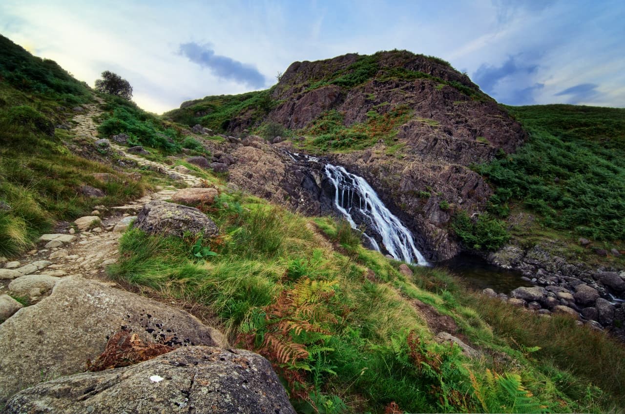
STOCK GHYLL FORCE
Ambleside is one of the more popular towns in the Lake District, featuring gorgeous scenery, plentiful walking, as well as its fair share of independent cafés, restaurants, pubs, shops, and more.
But did you know you can find a huge waterfall just outside the town centre?
Stock Ghyll Force is the waterfall in question and its located at the end of a beautiful woodland walk, around a mile outside the town centre. Historically the power of the water plunging down Stock Ghyll Force was utilised by people working in Ambleside to produce bobbins, processed fabrics, paper, and ground corn. In fact, there were at least 12 watermills that were driven by the power of the water from Stock Ghyll Force.
These mills, by and large, have disappeared now but you can still see the historical industry that this waterfall provided Ambleside.
Stock Ghyll begins life on the slopes of the hanging valley below Kirkstone Pass and The Struggle, cutting its way down the valley until it reaches about a mile outside Ambleside town centre. Here the river splits in two and drops about 70ft as a waterfall, where it rejoins as one river once again in the pools at the bottom.
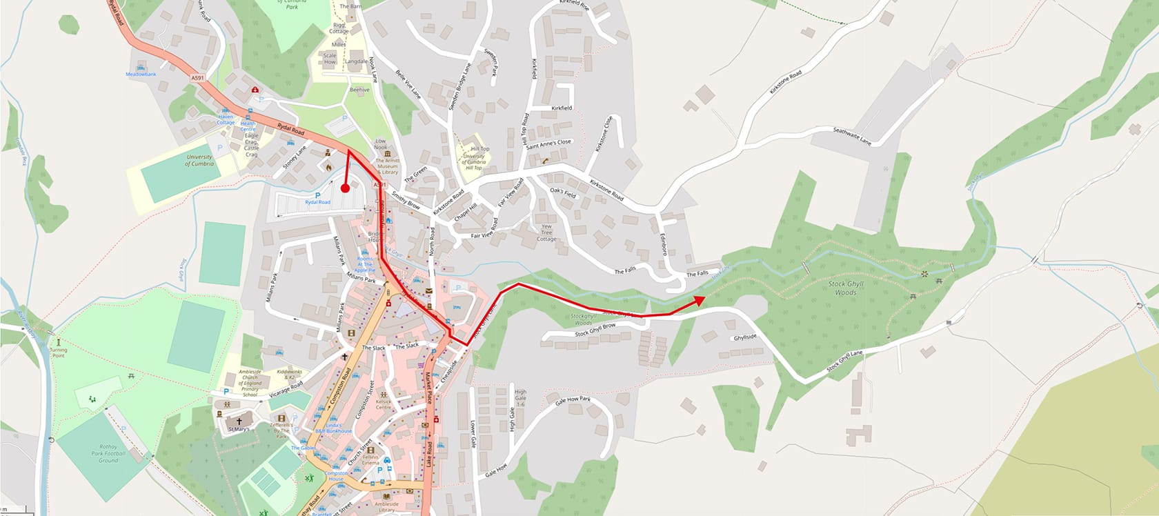
Walking to the waterfall is no real hardship but finding somewhere to park first could be a challenge; Ambleside is a key town in the Lake District and popular all year round. A good bet would be to head to Safer Lakes; this provides people with daily and almost hourly updates on all the car parks in the Lake District and how busy they are. A valuable resource.
A good car park to try first is Rydal Road Car Park (///workbook.soothing.punch), which has nearly 200 parking spaces.
To get to the waterfall from Rydal Road car park, come out of the car park and turn right alongside Rydal Road/A591. Follow alongside the A591, passing the famous Bridge House, Ambleside Post Office, and Ambleside Salutation. As the road bends right you'll see a little road branching off alongside the Doi Intanon restaurant. This is Stock Ghyll Lane, head down here and follow the lane as it bends left then right. Stock Ghyll Lane starts to gain in height but shortly you'll see a footpath branching off Stock Ghyll Lane and heading into the woods. This is the woodland that leads to Stock Ghyll Force.
The woodland is well signposted and you should find no problem making your way to the waterfall. There's two high viewing platforms either side of the falls as well, giving you incredible and expansive views of the waterfall in its gorge.
SKELWITH FORCE
In comparison to the two previous waterfall behemoths of Aira Force and Stock Ghyll Force, Skelwith Force is teeny with only a 15ft drop. But don't let that fact dissuade you; what Skelwith Force lacks in height it makes up for in power and accessibility.
Skelwith Force can be found just northwest of the village Skelwith Bridge, appropriately. The River Brathay exits southeast from Elter Water and meanders gently through Birk Rigg Park. About 300 metres from Skelwith Bridge the river enters a small gorge and gets "pinched" by the local geology, where it is forced through a narrow fissure in the rocks. The result is a small but extremely powerful and loud waterfall.
Skelwith Force is dead easy to get to and you can even, with care, get right next to the waterfall.
Come off the M6 at Junction 36 onto the A590 then take the 2nd exit at the Brettargh Holt Roundabout to get onto the A591. Follow the A591 passing Windermere until you get to Waterhead, just south of Ambleside. Here the road splits, with the A591 continuing to the right. Instead take the left-hand fork onto the A5095 through Waterhead. Just after Ambleside Rugby Club on your left you'll see a left turn signposted Coniston (A593)/Hawkshead (B5286)/Langdale (B5343), take this left. Follow the A593 until you see a right turn (signposted Elterwater/Langdale/B5343) with a big sign welcoming you to Skelwith Bridge. Take this turn. You can park along the left-hand side of this road, near the Skelwith Bridge Hotel, but spaces fill up quickly (///standing.affair.ferried).
Assuming you've managed to park up alongside the Skelwith Bridge Hotel, it's a short walk to the waterfall.
From the road, walk past the hotel until you see a yard open up to your left. This is the former site of Kirkstone Galleries, a showroom for the former company's stone finishing facility. Walk through the yard until you join the path and turn right onto it, with the River Brathay below you on your left. Just a 100 metres or so up the trail you'll see a sign for Skelwith Force with some metal steps leading down straight onto the waterfall. You can then clamber around the crags that frame the waterfall, but do be careful.
RYDAL FALLS
Photo by Andrew Bowden, licensed CC-by-SA-2.0.
Just southeast of Grasmere one can find the tiny village of Rydal and the grand house and gardens of Rydal Hall. This house was built in the 16th century and was the home of the Le Fleming family, before being substantially altered and expanded in the Victorian era.
Near Rydal Hall is the smaller house of Rydal Mount, known famously as William Wordsworth's home from 1813 until his death in 1850. Wordsworth would take frequent walks around the gardens and estate of Rydal Hall, especially the waterfall near the Hall known simply as Rydal Falls.
These falls are the result of Rydal Beck travelling from the open expanse of Rydal Head then entering a rocky ravine near Rydal Hall, crashing through several waterfalls as it cuts its way past Rydal to join the River Rothay, before finally draining into Windermere. The lower falls, pictured in this post, are easy to access and in fact there's a tiny viewing house right near the falls—known as The Grott—which holds the claim as the oldest viewing house in England (being built in 1669).
Getting to Rydal Falls is very easy. Come off the M6 at Junction 36 onto the A590 then take the 2nd exit at the Brettargh Holt Roundabout to get onto the A591. Follow the A591, passing Windermere, Waterhead, and Ambleside. Continue on the A591 north of Ambleside, passing the cricket grounds. Shortly after passing a sign indicating you've entered Rydal village you'll see a left turn over a bridge, signposted Under Loughrigg. Take this turn off, over the bridge, then turn immediately right after the bridge to head towards Pelter Bridge car park (///breathing.motor.factor).
The gardens of Rydal Hall, which contains Rydal Falls, are free to access, though donations for upkeep and maintenance are gratefully accepted. From the Pelter Bridge car park, walk back onto the path alongside the A591 and head north following the road. You'll soon enter the village proper, and see signs pointing you towards Rydal Hall. Once in the gardens of Rydal Hall it's easy enough to wander around, enjoying the scenery, and following estate signs towards the Grot and Rydal Falls itself.
SOUR MILK GHYLL
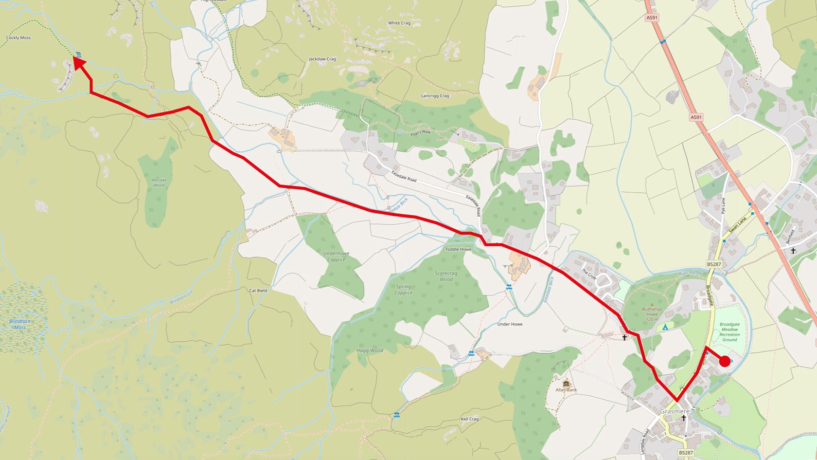
There's actually quite a few waterfalls in the Lake District named "Sour Milk Gill/Ghyll", which all likely have the same reason why: the brilliant white of the rushing water from these falls reminded people of sour milk. The one we're talking about is located near Grasmere on the way towards Easdale Tarn.
These falls were apparently once known as Churned Milk falls and were a favourite of Dorothy Wordsworth, poet and author, and sister of William Wordsworth.
Getting to these falls isn't technically difficult, and certainly not in terms of navigation, but the blocky path leading up near the falls can be a bit of a pull.
Directions: Come off the M6 at Junction 36 onto the A590 then take the 2nd exit at the Brettargh Holt Roundabout to get onto the A591. Follow the A591 all the way to Grasmere; you'll pass Windermere, Waterhead, Ambleside, and Rydal along the way. There's a few parking options in Grasmere but do be warned that they can fill up quickly, especially in peak season. A good option is Broadgate Meadows car park (///sprouting.inventors.shielding), which starts you off fairly near the walking route. You can also use contactless card payments at this car park.
To get to the falls, exit Broadgate Meadows car park onto Broadgate and turn left to head south along Broadgate, passing the Co-op and Barney's Newsbox shop. At the junction head right onto Easdale Road and follow the road passing all the housing. Before you get to the entrance for the Lancrigg Country House Hotel, you'll see a turn off left into the woods over a small slate footbridge. Take this path through the woods and onto the footpath track beyond. You'll know you're on the right route because the footpath features large cobblestones that are rather tricky to walk on.
You'll soon see the Sour Milk Ghyll ahead of you, a milky white stream flanked between two crags. Simply follow this footpath all the way. As you near the waterfall the path will bend to the left and start climbing fairly steeply. Take your time and watch your footing. You'll soon arrive at the waterfall and experience the incredible views from it for yourself.
Lake District walks for the first time visitors
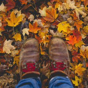
One of the most popular physical activities people enjoy doing in the Lake District is walking. And why wouldn't you? The Lake District is a treasure trove of trails, ready for those with a good pair of boots to explore the woods, valleys, ridges, tarns, and peaks of the Lake District.
Truth be told there are a near-incalculable number of trails and paths one can take in the Lake District. Rather than overwhelming you, dear reader, we've settled on summarising a few that are best enjoyed if you're a first time visitor to the Lake District.
Important points to note: a lot of walks we list below have clear paths and trail signage for easy navigation. Nevertheless, it is always advisable for you to have:
What3Words: an ingenious map and location service. What3Words divides the whole world in 3x3 metre squares, and gives each square a unique, permanent, and memorable three-word address. Increasingly, Mountain Rescue Teams in the Lake District are advising fell walkers to use this app. If you're in need of rescue, just open the app and relay your precise 3-word address to Mountain Rescue.
Lake District Weatherline: useful for checking weather conditions on the fell tops, Weatherline is mostly known for its Fell Top Assessors who hike up and down Helvellyn everyday during the winter to report on winter fell weather and walking conditions.
Safer Lakes: this is a wonderful service provided by the Lake District National Park Authority. Every hour, between 9am and 5pm, the Lake District's various car parks are patrolled and their capacity is reported to the website. There are 4 statuses: ? Not Very Busy, ? Fairly Busy, ? Busy, and ⛔️ Full. Try to park somewhere that is ? Not Very Busy.
Now you're armed with the relevant info and knowledge, here's some lovely walks to go on if you're in the Lake District for the 1st time.
Tarn Hows: A walk for all the family
Undoubtedly one of the most popular walks in the Lake District, especially for newcomers, is the walk around Tarn Hows.
Tarn Hows can be found a couple of miles west of the famous Lakeland village of Hawkshead. What is now a single tarn was originally three much smaller ones, known as Low Tarn, Middle Tarn, and (you guessed it) High Tarn. From 1862 the MP for Leeds, James Garth Marshall, gained possession of the area and started modifying the landscape by expanding the tree plantations around the tarn, and constructing a dam at Low Tarn that ultimately created the Tarn Hows we know today.
Tarn Hows is one of those Minimum Effort/Maximum Reward places. The trail around the tarn is only 1.75 miles, but offers variety from panoramic views, to waterside paddling, and woodland meandering. On the higher reaches of the trail the views take in the Coniston peaks (particularly Wetherlam) and even the tops of the Langdale Pikes.
Directions: Come off the M6 at Junction 36 onto the A590 then take the 2nd exit at the Brettargh Holt Roundabout to get onto the A591. Follow the A591 passing Windermere until you get to Waterhead, just south of Ambleside. Here the road splits, with the A591 continuing to the right. Instead take the left-hand fork onto the A5095 through Waterhead. Just after Ambleside Rugby Club on your left you'll see a left turn signposted Coniston (A593)/Hawkshead (B5286)/Langdale (B5343), take this left. Not long after this you'll see another left turn off the A593 that's sign posted for Hawkshead/B5286, take this exit. After nearly 2 miles on the B5286 you'll see a right turn signposted for Tarn Hows/Coniston, with a smaller ground sign advertising the Drunken Duck Inn, take this exit. Follow this road, and all the old signage, all the way to Tarn Hows and its National Trust car park.
The National Trust is quite large and is open from dawn till dusk. If you're already a National Trust member, then you can scan your card and park for free.
The walk barely needs any description for reference, here. Hop out of the car park (or walk, it's up to you) and follow the signage to the Tarn Hows circular trail. Take your time, watch your footing, give space and respect for others, leave no trace, and take only photos.
Orrest Head: Wainwright’s favourite view
In 1930 a young Alfred Wainwright, from Blackburn, Lancashire, arrived at Windermere and walked up the nearby fell known as Orrest Head.
And then, in his own words, “…quite suddenly, we emerged from the trees and were on a bare headland, and, as though a curtain had dramatically been torn aside, beheld a truly magnificent view…”
This experience changed Alfred Wainwright’s life forever. He moved to Kendal in 1941 and started working on his now-famous Pictorial Guide to the Lakeland Fells in 1952. Wainwright's Pictorial Guides have been in continuous publication since they were written and have sold more than two million copies. They have become the "standard" on how the Lake District is mapped and explored, so much so that a popular activity for Lake District enthusiasts is to summit The Wainwrights: 214 peaks named in Alfred's Pictorial Guides.
You, too, can follow in the footsteps of one of the Lake District's most famous characters. Orrest Head is not a challenging walk at all; the fell is only 238 m (783 feet) high and you'll actually ascend about 88 metres. This is very much another Minimum Effort/Maximum Reward walk, so whilst you won't be burning many calories it's still exhilarating to follow in the footsteps of Alfred Wainwright and experience the incredible view that changed his life.
Directions: Come off the M6 at Junction 36 onto the A590 then take the 2nd exit at the Brettargh Holt Roundabout to get onto the A591. Follow the A591 all the way to Windermere town. Before you get to the town proper, near the railway station, there's a layby just off the road that has a few parking spaces (///heats.butternut.lowest).
The starting point of the walk is just below the Windermere Hotel (///bandaged.sector.sprayed). You'll see a big sign that says "Footpath to Orrest Head", follow that footpath. The footpath follows a wooded lane, then you'll see a right turn at a junction. Take this turn off and you'll start ascending up and to the left. The path will then turn right and follow alongside a stone wall, which will be on your left. Follow this wall then turn left up the steps towards the summit of Orrest Head.
And then... enjoy.
Friar’s Crag: Minimum effort for maximum reward
Perhaps the Grand Champion of all Minimum Effort/Maximum Rewards walks in the Lake District is the short walk from Keswick to Friars Crag.
The crag juts out about 15–20 ft above the waters of Derwentwater, and its position just south of Keswick boat landings means it offers almost unparalleled views down Derwentwater towards the famous Jaws of Borrowdale.
Famous Victorian art critic and social reformer, John Ruskin (whom we talked about before regarding Coniston), said that the view from Friars Crag "is one of the three or four most beautiful in Europe". There is in fact a memorial to John Ruskin on the approach to Friars Crag.
Other creatives have been awed by the view offered at Friars Crag, such as Romantic poet Robert Southey, who said, "If I had Aladdin's lamp, or Fortunatus's purse, I would here build myself a house." J. M. W. Turner, the famous English landscape painter, painted the view from Friars Crag in either the late 18th or early 19th century.
Directions: Come off the M6 at Junction 40 onto the A66 west. Follow the A66 all the way into Keswick town centre. There are numerous car parks dotted throughout Keswick (such as Otley Road, Bell Close, Lakeside etc.) but you may need to drive around before you find a suitable space as Keswick can get very busy.
Getting to Derwentwater lake from Keswick is easy. Starting from the Keswick Herdy shop (///clerk.orbited.sprint), head up Tithebarn Street towards the roundabout, and head right onto Main Street. Follow Main Street through the Market Square and once you've passed the Moot Hall Tourist Information building take the right path that forks alongside the Old Keswickian Chippy. This is Lake Road.
Follow Lake Road until you get to the junction at George Fisher and turn right, staying on Lake Road. Come off Lake Road when you can see the subway and head through the subway. This will bring you out into Hope Park. Follow the path through or alongside Hope Park all the way towards Keswick boat landings. Stay on the path and follow the signs to Friars Crag. The walk from Keswick town centre is about 20 minutes.
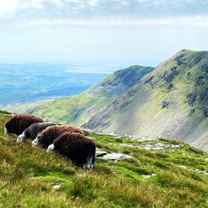
Catbells: A great first peak to bag
If we were to take an educated guess on which fell most fell walkers tackle as their first, it would probably be Catbells.
Viewed from Derwentwater the fell presents itself as an attractively shaped peak, which changes colour wildly between the seasons: red in the winter, and green in the summer.
See the peak in the middle? That's Catbells.
The name might seem weird, which is fair enough. It's not certain where the name comes from, but local legend Alfred Wainwright suggests it's a corruption of "Cat Bields", meaning "shelter of the wild cat".
Catbells, or Cat Bells, is one of the smaller Lake District fells at only 451 m (1,480 ft), a good 1,729 ft shorter than England's tallest peak Scafell Pike. However, what it lacks in height it makes up for with the staggering views it offers from around the summit.
Photo by Andrew Bowden, licensed CC-BY-SA-2.0
Directions: there are limited spaces at a layby right where the walk up Cat Bells starts (///adobe.endearing.sweat). Come off the M6 at Junction 40 onto the A66 west. Follow the A66, bypassing Keswick as you do so. After around 20 miles on the A66 look out for a left turn, signposted Grange/Portinscale/Newlands valley. Take this turn and follow the road through Portinscale village and into Fawe Park woods, following the signs for Hawse End Centre.
The trail starts at ///immunity.bypassed.outbound. The walk is short but steep; just stay on the trail, which is clear and paved in places, all the way to the summit. There's a small amount of scrambling required to get to the summit. But remember, it's not a race! Take your time, enjoy the views, and drink in the experience. Give yourself 2.5–3 hours to ascend the summit and make your way back safely.
Skelwith Bridge to Elter Water: Coffee at one end, beer at the other
If you want a walk that's away from the more popular lakes, but still offers incredible scenes, we can definitely recommend the walk from Skelwith Bridge to Elter Water.
You'll note that we've mentioned Skelwith Bridge before when talking about the waterfall near there. The walk to Elter Water starts exactly the same as if you were visiting Skelwith Force, but then continues on.
Elter Water is one of the smaller lakes in the Lake District. It's unusual in that it's "bottle-necked" in two places, which almost cuts the lake into three separate lakes. The eastern section is the main body of water that you're able to access on this walk.
The name, like many place names in Northern England, comes from Old Norse: elptr or alpt, meaning "swan", and vatn meaning "water", giving us "lake of the swans". Indeed, to this day, Whooper Swans still winter on the lake.
The walk from Skelwith Bridge to Elter Water is gentle, clear, and offers some of the finest views towards the famous Langdale Pikes. Here's how you get here.
Photo by Andrew Bowden, licensed CC-BY-SA-2.0.
Directions: Come off the M6 at Junction 36 onto the A590 then take the 2nd exit at the Brettargh Holt Roundabout to get onto the A591. Follow the A591 passing Windermere until you get to Waterhead, just south of Ambleside. Here the road splits, with the A591 continuing to the right. Instead take the left-hand fork onto the A5095 through Waterhead. Just after Ambleside Rugby Club on your left you'll see a left turn signposted Coniston (A593)/Hawkshead (B5286)/Langdale (B5343), take this left. Follow the A593 until you see a right turn (signposted Elterwater/Langdale/B5343) with a big sign welcoming you to Skelwith Bridge. Take this turn. You can park along the left-hand side of this road, near the Skelwith Bridge Hotel, but spaces fill up quickly (///standing.affair.ferried).
From the road, walk past the hotel until you see a yard open up to your left. This is the former site of Kirkstone Galleries, a showroom for the former company's stone finishing facility. Walk through the yard until you join the path and turn right onto it, with the River Brathay below you on your left.
Follow this path past Skelwith Force and out of the woods, you'll clearly see the path ahead of you winding its way through the fields with the Langdale Pikes looming above in the distance. Simply follow the path all the way until you reach the shores of Elter Water (///square.constants.plunger).
Gummer’s How: The sequel to Orrest Head
Photo by mattbuck, licensed CC-by-SA-3.0
Gummer's How presents itself as a wonderful alternative if you've been up Orrest Head, or feel that something like Catbells might be a bit too much for you.
The fell really isn't that high, measuring 321 m or 1,053 ft, but it's relative isolation and close proximity to the shores of Windermere means it offers one of the best views across the lake towards the Lake District fells. In fact, so panoramic is the view from Gummer's How, that you can even make out Morecambe Bay and beyond on a clear day.
Photo by mattbuck, licensed CC-by-SA-3.0
Thankfully, the walk up to Gummer's How is served by a fairly sizeable car park, located at ///wades.crumple.report. Getting to the car park is no hardship either. Come off the M6 at Junction 36 onto the A590 then take the 1st exit off the Brettargh Holt Roundabout to stay on the A590. After 12 miles or so on the A590 you'll enter Newby Bridge village, located right on the southern tip of lake Windermere. At the main roundabout of the village, take the 2nd exit signposted for Bowness/Windermere/A592. Just under a mile after this you'll see a right turn off the A592 signposted Cartmel Fell/Bowland Bridge and Gummers How Picnic Area. Take this turn off, head up the steep road and follow it all the way to the car park.
Photo by mattbuck, licensed CC-by-SA-3.0
The walk from the car park to the summit of Gummer's How and back will take you roughly 45 minutes.
Head out of the car park and continue up the road to find a wooden kissing gate signposted "Public Footpath to Gummer's How summit only". Head through here and walk towards Gummer's How away from the wall. Follow the path alongside a small tree plantation, it then crosses a stream and starts to climb, gently at first then more steep. Eventually you'll come face-to-face with the crags of the summit itself; the path forks here, but take the right-hand path and follow it as it makes a beeline for the summit.
Feel free to meander around the craggy summit of Gummer's How and gawp at all the views it has to offer.
Scout Scar: a Kendal favourite with amazing views
A great option for your Lake District stay is the historical market town of Kendal, which is also the home of our Kendal Herdy Shop and Herdy HQ itself!
We've touched on Kendal before, and you can read about all the things you can do in and around Kendal here.
Kendal makes a great base for further exploration of the Lake District, whether that's Windermere, Ambleside, or Grasmere, further north towards Shap and Haweswater, or south into Coniston.
But there's a beauty of a fell right on the doorstep of Kendal that you and your family can enjoy with very little effort. And best of all, the views are spectacular.
Scout Scar—otherwise known as Underbarrow Scar—is only a tiny fell reaching 235 m or 771 ft high, but the views it offers from its cliffs are absolutely sensational. This is because Scout Scar is a limestone escarpment; its eastern profile is a gentle rise from Kendal until it reaches its western ridge, which suddenly plunges down a long cliff to the Lyth Valley below.
Looking directly east from the cliffs of Scout Scar you are offered incredible views across the rolling Lyth Valley to the craggier Lake District fells such as the Langdale Pikes and Coniston Old Man. Northwards along the cliff you can make out the more rounded profile of the Far Eastern Lake District fells; looking south takes in the Kent Estuary and even the expansive waters of Morecambe Bay.
The walk up to Scout Scar is very straightforward.
There's a Lake District National Park car park right at the start of the walk (///vocab.skills.darker). Come off the M6 at Junction 36 onto the A590 then take the 2nd exit at the Brettargh Holt Roundabout to get onto the A591. After two miles take A6 slip road, signed posted for South Kendal/A6. Follow the road all the way into Kendal until you reach the main town centre junction with the Town Hall clock tower. Take a left here and follow the road up Beast Banks, onto Greenside and onwards east out of Kendal. The road will climb higher, and cross over the A591. Look for the car park on your right.
After parking up, cross the road, enter through the gate, and follow the very short path up onto Scout Scar. And then, have a wander and enjoy those views.
Sign up for our newsletter and you'll automatically be entered into our monthly prize draw, ewe could win £100 worth of Herdy goodies!
Enter your email address
You can change your mind at any time by clicking the unsubscribe link in the footer of any email you receive from us, or by contacting us at hello@herdy.co.uk. We will treat your information with respect. By clicking to Join Us, you agree that we may process your information in accordance with our terms.


 The woodland is well signposted and you should find no problem making your way to the waterfall. There's two high viewing platforms either side of the falls as well, giving you incredible and expansive views of the waterfall in its gorge.


 You'll soon see the Sour Milk Ghyll ahead of you, a milky white stream flanked between two crags. Simply follow this footpath all the way. As you near the waterfall the path will bend to the left and start climbing fairly steeply. Take your time and watch your footing. You'll soon arrive at the waterfall and experience the incredible views from it for yourself.